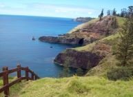
Norfolk Marine Park habitat mapping projects

Parks Australia is funding two exciting Our Marine Parks Grants programs for habitat mapping in Norfolk Marine Park. Together, these eagerly anticipated projects will, for the first time, give us a detailed and current understanding of the underwater ecosystems surrounding Norfolk Island.
One project, led by Pendoley Environmental, will focus on understanding near shore habitat. A second project, led by iXblue, will focus on the environment further offshore.
Weather dependant, offshore survey work is scheduled on the vessel Offshore Solution from 21-26 July – so keep your eye on the horizon for a glimpse of the ship. The consortium of research partners for this project include: iXblue, the University of Wollongong, Deakin University and Tellus4d Geoimaging. The team will be working around the island for five days mapping the seabed.
The equipment onboard the Offshore Solution will produce high-resolution images (via multibeam bathymetry and sub-bottom profiling) which will allow us to better understand the unique geomorphology surrounding the island. The project will also include some coastline drone mapping later in the year.
The iXblue project has been working closely with Kellie Pendoley (nee Lorking) and her team, including Mitch Graham, Rob Ryan, and Marg Christian, who will be doing inshore habitat mapping and ‘ground-truthing’ in the coming months.
Baited, underwater camera systems (BRUVs) will be deployed as part of the iXblue project to identify fish species and their associated habitat types. Environmental DNA (eDNA) samples will also be obtained through general water sampling techniques to identify the presence of specific species.
The overarching goal of the mapping is to link the onshore geology to the offshore marine habitats and produce detailed maps of the ecosystem present in Norfolk Island’s waters. This will help us in our management and protection of Norfolk Marine Park by locating particularly sensitive or biodiverse habitat areas. We also hope it will be a great resource for the community to learn more about your marine treasures.
While the iXblue team will not be able to visit the island this trip due to COVID-19 restrictions, members of the offshore mapping project team plan to come to Norfolk to share their results with the community later this year.
If you have any questions about either of these projects, please contact us at norfolkmarinepark@environment.gov.au
Hilary Schofield – Director – Marine Parks Management
Fran Murray – MPA Management (South)
Jim Castles – Norfolk Marine Park Project Officer


Sign up for Norfolk News
Sign up for our monthly newsletter to receive updates about Norfolk Island National Park.