
Hunter Marine Park extends from shallow shelf waters out to the deep ocean. It includes shelf rocky reefs and canyons.
Tuna, albatross and whales feast here, benefitting from upwellings of nutrient-rich waters where ocean currents meet the canyons. Humpback whales and grey nurse sharks also use the area as a feeding ground.
Over 50 of the fish species that live in this area are endemic; they aren’t found anywhere else. Fishing is a significant activity in the region, and includes commercial fishing, recreational fishing, charters and game fishing tournaments.
The marine park adjoins the New South Wales Port Stephens-Great Lakes Marine Park, offshore from Port Stephens in central New South Wales.
It covers 6257 square kilometres, with depths from 15 metres to 6000 metres, and includes a Habitat Protection and Special Purpose (Trawl) zones.
Click on the map below to see what you can do in the Hunter Marine Park.
Explore
Hunter Marine Park and the adjacent New South Wales Port Stephens–Great Lakes Marine Park are great places to fish and watch wildlife.
You can join a fishing charter or whale-watching tour from Port Stephens and Nelson Bay. Find out more about the Port Stephens–Great Lakes Marine Park.
Discover
Humpback whale. Photo: Eric Woehler
The Worimi People are the Traditional Custodians of the Port Stephens area. The Worimi People have strong cultural connections to Sea Country (garuawa) including within Hunter Marine Park and neighbouring, state managed Port Stephens-Great Lakes Marine Park.
These important cultural connections were celebrated in a collaboration between the Worimi People, artists Melissa Lilley and Deborah Dates, Parks Australia and the New South Wales Department of Primary Industries.
Barayalbu – The ‘Big Song’
 Barayalbu – The ‘Big Song’ © Melissa Lilley (Mombie), 2020
The artwork depicts species of cultural significance and illustrates the interconnectivity between people and place. Song-lines extend from far inland mountain (balgarr) areas out into deep ocean (garuwa).
Girambitbaa – Saltwater Place
 Girambitbaa – Saltwater Place © Melissa Lilley (Mombie), 2020
The artwork illustrates Worimi people’s cultural calendar and shows the relationship between significant species and elements that coincide with resource availability. Wind, sea temperature, land and air temperature, native plants or animal lifecycle and even cycles or the moon and stars were used to inform of resource availability and associated cultural activities.
Buna Wambul – Sea Beach
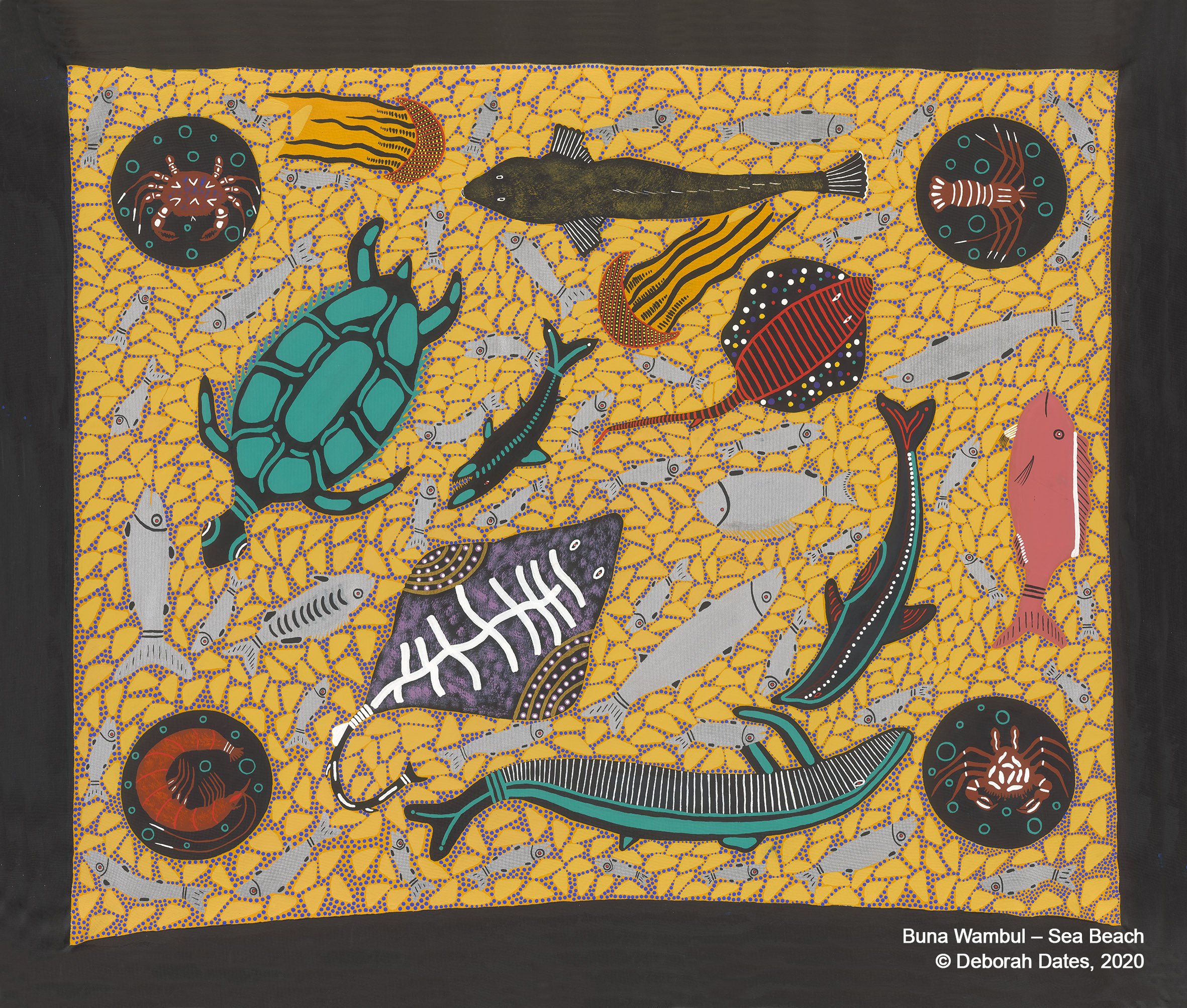 Buna Wambul – Sea Beach © Deborah Dates, 2020
In Worimi communities there are ceremonies and cultural practices that create links between Aboriginal people and the environment. One of the main cultural systems that influences connection to Country is the assigning of totems for individuals, communities, and Aboriginal Nations. The artwork illustrates Sea Country animals of cultural significance or those identified as totems.
Garuwa – Sea Country
 Garuwa — Sea Country © Deborah Dates, 2020
The artwork illustrates the interconnectivity of species and the environment. Land and Sea Country work as one, and species utilise features of both depending on their specific needs. Whether this is feeding sites in open waters, or breeding sites on nearby Islands, species utilise benefits where it can be found.
To read the three stories and learn more about Worimi People’s cultural connections to Sea Country, please download the Understanding the cultural values and uses of Worimi sea country.
Download detailed map
Activities in marine parks
Allowed activities
Learn more
Contact us


Stay in touch
Subscribe to receive important updates about your marine parks. Enter your email address and click "join now".